Monday, November 13, 2023

November 12, 2023 Going Home

I got to explore this morning.  I got to roll, and roll.  It felt so good.

My morning walk took me to the Riverwalk.  Spouse came with me for a while.  I used to be able to walk the entire distance to the end, but at the Colorado Belle, it becomes impossible to connect to the trail, so I headed back.


We let the GPS navigate for us.  She took us on the 163, to the 95.  Usually, we take the frontage road down to I40, but, I hate to admit it…  we liked her route.  It has some mountainy grades, but it is a 4 lane highway to 95 and a much cleaner road than the frontage road. 

Back on I40 (yawn).  Our trip cannot be complete without at least one stop at a Dairy Queen for Spouse to get a blizzard. 


Once again, we took the 58 to Mojave and caught the 14. It is longer than the Pearblossom highway, but so much easier to drive.  And we heard about the issues with I10 and the fire, which was impacting every other freeway nearby, including the 15.  I am so glad we were able to avoid that drama.

Back at home…  5000 guavas on the ground…  we have a lot of work to do!

In general, I am very impressed with how Artee handled camping off the grid.  I see more of that in our future.


Saturday November 11, 2023 Visiting Jake

Is that a fly?  Get it!  I need a nap.

My morning walk took me into the desert near Lynn’s house.  In the cool of the fall, it is a great walk. There are several trails, it is a nature preserve with mesquite, cacti and rocks.  But alas, gotta get back.

Lynn made us a breakfast and then we headed to the rehab facility to visit Jake.  He recognized us and his wit and sarcasm are totally intact.  We participated in his rehab exercises.  They were fun, so why not.  It is a very nice facility.  Hopefully, Jake will be home for Thanksgiving.  Lots of family coming in for him. 

After our visit, Lynn brought us back for us to hit the road.  Always good to visit friends.

We got Artee ready, and hit the road.  The GPS is on, but I did the navigation.  We navigated over to Hwy. 93, which is a diagonal north to Kingman via Wickenburg.  The sassy saguaros entertain us, then the Joshua trees… then the boring dull desert.  We decided to head to Laughlin for the night.

As we pulled into Laughlin, we hit traffic.  Really??? Oh… the traffic light is out.  Ok… wait… that light is out too.  Hey, all lights are out.  This ought to be fun…  We pulled into the Riverside RV park, where they put is in overflow parking (which I really like).  We hooked up assuming the electricity will come on at some point, and it did.

We headed over to the casinos, had dinner, and won $22 between the two of us!  Yay!  Life changing!


Friday, November 10 Leaving the Big Ditch

Mrouch!  Stop moving me!

Woke up to 30 degrees.  Brrr…. Put on my ski pants to do my morning walk.  There are great trails around here.  Spouse started with me, but went back early on.  I wandered up this trail, over to that trail and ended up on the Rim Trail.  The sun was shining and the thermometer might have said in the 30’s, but that sun made it quite warm.  I shed my gloves and beanie and unzipped the jacket.  I wasn’t exactly sure of where I was going, but if I looked for the first cutoff on the Rim Trail, it should take me back to where I need to be, right???  The first cutoff deposited me in the parking lot of the visitor center.  Sooo, where does the trail pick up?  I went down the first aisle down the street, and just followed the street hoping I would find the trail.  And I did… 

Back at Artee, we readied her for the road.  We are headed to Phoenix to visit friends.  Spouse wanted to take Hwy. 64 east to Cameron, the same way we came in.  Now, so many people think of the Grand Canyon as a desert.  But the mesa at the top is at high altitude, almost 7,000 feet.  We are in a pine forest.  Big, tall, lodgepole type pines for miles.  As we head east, smaller pinyon pines take over and the arid desert comes into view.  We stopped at ‘Desert View’ which is a medieval type tower created by Mary Coulter, one of the major architects of a lot of the projects in the park in the early 1900’s.  At this point, there is a great view of the Colorado River, and you can climb higher in the tower for higher views.  A TWA plane crashed here in 1956, and it is a historic site.


Moving on… Rudy complains every time we move him from the truck to Artee and back.  Don’t bug me… tough, kitty.  Sometimes, we are the bosses!

At Hwy. 89, we head south to the I40/I17 interchange south.  The terrain is mountain with pines.  The grasses are brown now, and you can tell there has been a forest fire.  It is rocky, and piney til we are south of the Sedona turnoff.  Then the pines start thinning out but the rocky terrain continues.  It isn’t til we are about 40 miles north of Phoenix that the Sonoran Desert makes its appearance.  Saguaros start popping up.  Saguaros are amazing.  They each have their own story.  Some have lots of arms pointing up as if they are being robbed.  Others might have their arms pointing down, being obstinate.  There is one that looks like it is holding a dance partner in a waltz.  That one looks like it is flipping the bird.  It is fun for me to imagine their story.

As we approach Phoenix, there is construction everywhere.  I17 is being widened.  Houses are being built.  Where Phoenix, Scottsdale, Mesa, and friends used to be individual cities, they all run together now making a megalopolis just like Los Angeles, complete with traffic.

And of course…  As much as we need the GPS, I hate her.  She creates routes that are sometimes ridiculous.  Once I get to our destination, it is not unusual that I realize she is messing with us; making us take the wrong offramp and doubling back, you know, things like that.

We set up in front of Jake and Lynn’s house.  Jake is in a rehab facility after a stroke. We will see him tomorrow, and visit with Lynn tonite.  Always fun to visit good friends.


Thursday November 9, 2023  Kaibab and the Elk

My human let me out today.  She stood back and watched.  I saw two big black birds.  I wanted them.  I stalked them.  My human picked me up.

It was 35 degrees this morning.  After a good breakfast, we headed over to the South Kaibab Trailhead.  We saw the sign but they do not allow parking.  Hmmm, shuttle only.  Hmmmm, we parked down the street a bit and started walking the Rim Trail and realized it would be a long walk before we even started the hike.  So, back to the truck.  We drove to the Visitor Center and hopped on a shuttle.  As it pulled up to the trailhead, a herd of elk sauntered by.  There is a mule station right here, so something tells me they hang out here for the free food.


The Kaibab Trail starts as a series of steep switchbacks.  After all, you are going down into the canyon.  We had no intention of hiking down to the river, but wanted to enjoy a fair hike without killing ourselves.  After a while, the trail follows the side of the wall.  No tripping here.  You can go down 30 feet, or 300 feet, or…. And you will never get back up to the trail; thus the helicopter rescue we saw here yesterday.  It is cold in the shade, but the sun is out.  When Spouse declared he was done, I continued on down to ‘Ooh Ah Point’, obviously named for the views.  You can crawl up the rocks and get a picture… or you can fall and never be seen again!  I got someone to take my picture as I was wedged between the rocks… safely.  Hoofing it back up to Spouse was slow.  This was a steep part of the trail.  Slow… slow… slow… Can you hear my heart pounding?  Back to Spouse, we shed our jackets into my backpack and began the slow ascent.  A lot more people are coming in now.  We are glad we got an early start.


We hopped back on the shuttle, then did a bit more walking on the Rim Trail.  The views never get boring.

Back at camp, we were surprised to see a Bull elk sipping off the hose that was in an RV.  Beautiful critter!  Like right there!  Looks like that RV has a leak.  Maybe more will come in to enjoy it!


I am a bit surprised at the amount of people that are here.  It is quite busy.

Tomorrow, we head to Phoenix to visit our friends Jake and Lynn.  Jake has had some major health issues so we thought a visit might be good.  And then we will head home.


Wednesday November 8, 2023 The Non Mule ride

My paternal human let’s me share some of his food.  He shows it to me, I lick it.  It is so good.  Oh oh… hack hack hack thwack…  right in front of my humans… oh no.

It was 36 degrees this morning when we woke up.  Spouse has us on a waiting list to do a mule ride at 11, so at least we can wait for it to warm a bit.  We did take a small walk out of the RV park on a walking/bike trail through the pines.

We made a good breakfast and headed to Bright Angel Lodge to see if mule spots opened up.  Only one had… guess we will ride bikes.  But first, let’s walk around here.  Oh, more of the same… spectacular views.  In one of the shops, Spouse saw a mug that acts as a thermos.  He said as the ‘new Doug’ I should buy it… till he saw it cost $35.  The old Doug came right back!

We came back to Artee and got on our bikes.  Out of the RV park, there is lots of riding.  We checked out the campgrounds which are beautiful, but they will accept RVs no longer than 30 feet.  Lots of trees and very pretty.  We then rode on the greenway up to the Rim Trail.  At this point, bicycles are ok.  As we rode, we watched a helicopter hover on the edge.  It looked like it lowered something and hovered near the edge.  Then, it ascended with what looked like someone dangling a couple hundred feet below in a basket.  Now, riding a bike is really cold right now.  I have a T-shirt, flannel shirt, fleece vest and a gortex jacket on.  It is COLD!  I can only imagine how cold it is hovering thousands of feet in the air while the helicopter gets in position to deposit its load.  BRRRRR! 


Interesting to watch though.

We continued on the Rim Trail, through the trees, then through a short bare area, then more trees, until we got to the South Kaibab Trail.  Lots of park rangers.  We were told by someone that they were doing investigating and that parts of the trail were closed.  Hmm…  my true crime podcast mind got active!  Was the person in the helicopter pushed? Probably just another moron that didn’t take the trail seriously and wanted to get ‘just the right’ picture…

At that point, we started pedaling back.  We stopped at the market.  They have a pretty good grocery store here, and it is right near the RV park.  Perfect!

Spouse has been sharing an ice cream with Rudy every night.  Tonite, Rudy chose to throw up on my chair.  yuck


Tuesday, November 7, 2023  We aren’t in Kansas any more Toto

It’s noisy.  I will cuddle with my paternal human.

I did not sleep much last night.  The winds were horrendous.  I predict we took some damage.  When Spouse finally woke up after a wonderful sleep, I told him we need to get out of here NOW!  He laughed at me.  I told him I think there is damage.  The wind howled, thinks flapped, groaned, pounded.  I know something has to be damaged.  He laughed at me… until we tried to bring in the slider…  and it came in crooked.  He stopped laughing…  We immediately moved it out.  Spouse went outside and saw that the wind had popped the awning that is attached to the slider off.  Oh great, we just need two 8 foot ladders and this will be an easy fix.  Yea, like that is going to happen.

Spouse used the ladder attached to the back of Artee to crawl on the roof to assess the damage.  Well, we could do this, we could do that…  but we really need a ladder.  I went and checked the vacant Indian Trading Post and there was a short ladder.  Then the girl got an idea…  Let’s disconnect the truck and move it aside Artee and it can become the ladder.   Spouse actually agreed that it might work!  Voila!  Spouse was able to put it back in place. 


Now, let’s get the hell off this ridge out of these winds! Hrumph… laughing at me… 

Hwy. 64 is where you can see your first views of the Big Ditch.  There are lots of lookout points.  Once we entered the actual park, we headed to the visitor center and walked some on the Rim Trail.  The Rim Trail goes for miles, some of it, you can ride your bikes, but near the visitor center, it is pedestrian only.  We have been here many times, and it is still breathtaking.  Or, is that the frigging winds sucking the life out of us…  At least the pine trees provide some protection.  The temperatures are warm, but the winds are really cold.  They finally subsided about 5 pm. 


We got to our spot and set up.  ELECTRICITY!  This is a decent RV park. Lots of pine trees, and the spots are not horribly close to one another.  But it is an RV park…

Spouse is going to work on cleaning the contacts on the GPS.  As much as I hate the bitch, she does come in handy.


Monday, November 6, 2023 – Leaving Lake Powell

If I crouch down, I can see my human’s paw under the door in her potty room.  Let me reach out to her.  I know she will let me in.

My morning walk took my down the road.  Near the launchramp, I walked out onto a promontory overlooking the lake.  Down this way, just 60 miles, is Wahweap.  I then walked the road to the Marina cutoff.  Back to listening to me podcasts.  When I got back, we got ready to move on.


Rudy has been obsessed with our bathroom.  I could be on the toilet and his paw is reaching under the door.  I let him in and he jumps on the sink and expects we to put water in it for him.  Of course I do…

Now we get to retrace our steps back to Blanding.  Our GPS is not cooperating.  Seems it cannot acquire its satellite.  Oy..  We have paper maps which will do for now. Some of the road is so boring, but other parts are quite pretty.  Based on the trees, you can tell there is a creak following the red rock outcroppings.  They still have some green, but they are starting to turn yellow.  There is open rangeland, so we have to slow for the cows now and again.  After 60 miles on Hwy. 276, we hit Hwy. 95.  We have yet to see one other car.  From that point about 40 miles to Hwy. 191, we saw about 5 cars. 

There is a fly inside the truck.  I have named it Marty McFly.  We must get rid of him…  Rudy is totally disinterested, worthless furball!


We head a few miles up to Blanding to fill our propane tank.  Living off the grid and using our generator does burn some propane.  While there, I was able to get Marty McFly out!  We fueled up, bought a few groceries and started south.

Our ultimate goal is to go to the Grand Canyon.  Whether we get there today is another thing.  We take Hwy. 191 south to Hwy. 163.  Lots of mesas and buttes.  Some of it is pretty, some of it is boring.  We decided to get reservations in the RV park at the Grand Canyon starting tomorrow.  I begged the guy to get it all down quick as we were headed into ‘no cell’ territory.  As he tried to give me my confirmation, we lost him…  Bwahaa!  We got a confirmation.

It is a bit windy.  We see desert sands creeping across the road.  At one point, we thought we would stop at a little spot west of Kayenta.  There is an old hotel, and across the street is a nice pullout.  We have stopped there for lunch a few times.  But when we got there, the hotel is gone and there is a sky high pile of gravel in the pullout.  So much for that idea!  We continued to Tuba City, then turned south on Hwy. 89.  It’s about 4 pm, and normally, we are off the road by 3.  But we figured it’s just a short jaunt to Hwy. 64, which will take us to the Big Ditch and we will pull over somewhere there.  And that is exactly what we did.  Found a nice pullout by some Indian Trading Posts that were vacant, and we set up for the night.

It is a bit windy, but we had a nice view.  Let me correct this… it is crazy windy.  Oh my, this is going to be one hell of a night…


November 5, 2023 More of Lake Powell         

My humans are letting me outside without a lead.  They stick close to me, but I am loving sniffing, rolling and wandering.  Then I get bored and go sit on the steps and they let me in where I can take a nap.


The weather here has been great.  It is cold in the mornings (low 40s) but gets up to about 70 during the day.  I actually did a morning walk today.  I walked over to the launch ramp.  It is a long launch ramp but only about 50 feet of it is left for launching, otherwise your tires will go into the mud.  There are only 4 vehicles in the parking lot so it is not busy.  Hopefully a wet winter will add to the water levels.  I watched all sorts of fish swimming around; little ones, big ones.  Obviously they are not worried about anything!

Spouse has been talking to Igor.  His real name is Steve and he is a retiree.  I have taken him off my list of serial killers!  He really is quite nice.  Just a bit on the reclusive side.  He warned us off the road we were planning on taking out of here, so we will reroute ourselves.

After a leisurely morning, we got on our bikes and did some more pedaling.  We checked out the residential area, then pedaled up a dirt road.  Well, it had a lot of rocks too.  We bounced around for about a mile til we got to a water tower.  An amazing view of the lake presented itself.  After bouncing back down the trail, we headed back.


Let me give you a little personal Lake Powell history.  In the late 80’s and early 90’s, we used to come here every year.  Our friends Rick and Sue with their kids and friends often came, as well as my sisters and kids, and Doug’s daughter.  We would pack all of our belongings (bathroom, kitchen, living room, bedroom) in the boats and head back to the Dangling Rope Marina area, about 25 miles from Wahweap.  There were a few areas of somewhat level ground where we could set up camp.  We would regularly head over to Dangling Rope and have an ice cream, buy fuel and ice and just people watch.  Oh, they had flushing toilets which was really nice.

Sad to say, Dangling Rope is no more.  With the water issues, it was closed.  Apparently, for 2 years it sat with all of the goods still inside.  They have since moved the fuel docks up to Hall’s Crossing.  This has significantly changed the dynamics of the lake.  Without that marina, folks like us really couldn’t camp in that area for any length of time.  You need fuel and ice to make it and if you have to schlep all the way to Wahweap, that would be a real problem.  Without Dangling Rope, it is about 60 miles from Wahweap to Hall’s Crossing.  In boating terms, that is a real long way!  Plan to have a jerry can of fuel on board just in case.  It is a $600 an hour tow if you need it.  Ouch!

Houseboats have the room to store jugs of gas, so I guess they rule the territory now. 

Another thing affecting Hall’s Crossing is the fact that the ferry is no longer running between Hall’s Crossing and the more popular Bullfrog.  Without that connection, hwy. 276 does not exist as designed.  Hopefully, we will get a wet winter.

After a leisurely day, we relocated to the RV section of the park.  It isn’t open, but the electricity works and we can dump our tanks.  We really did try and pay, but they can’t take the money so, we will take advantage of it. 

We have electricity!  We did some cleaning and Spouse dumped tanks.  We showered and were a bit frivolous with our resources!  Our generator has been   great, but it does suck propane.  It is nice to be able to not think about it.  The down side of this is that the park has not been maintained and there are sticker plants all around.  We need to pick them off our shoes and Rudy.  Another good side is that the flies we had at the campground do not seem to be a problem here (although we did import two little bastards from there…  just can’t seem to nail their asses!).


Saturday, November 4, 2023  Lake Powell

Hack, hack, hack… thwack!  Shh, don’t say anything and maybe the humans won’t notice my mess.  Just look cute.

It was 41 degrees this morning.  A far cry from the 20’s of the night before.  It is expected to get up to about 70.  YES!  During the night, I looked outside at the dark night sky.  Saw shooting stars.  The moon is finally waning so we actually get some good viewing.

We walked around a bit, then came back and unloaded the bikes.  It is warm, it is cold.  Dress accordingly.  Once we got going, it was quite cool.  We had talked to the other camper here.  They were going skiing in this beautiful glassed out water.  But they have wetsuits…  Oh, I wish it were me!  But I will enjoy the bike ride. 

We headed to the marina.  The water level is obviously low.  We can see the bathtub ring from years gone by.  We walked down quite a bit to the docks, talking to the few people we saw.  A lady offered to take us over to Bullfrog if we wanted to rent a boat.  The only problem with that is we would have no way back when we were done. 


We looked at all the beautiful houseboats.  I liked the one named ‘No Sniveling’.  I betcha I would like these people!  The store was still open, and will be through winter, but there is nobody here to speak of.  The cashier told us they are having trouble getting labor and made an attractive pitch, but I didn’t fall for it!  As much as I would love it here, I don’t want to work.  Although I could see the fun in it.  We are really in the middle of nowhere.


There used to be a ferry between Hall’s Crossing and Bullfrog.  But it closed in 2019.  We pedaled to where the loading was.  You could see the ferry anchored offshore.  There is probably 200 feet of dirt from the loading ramp to the water.  I don’t expect to see that ferry operating any time soon.


There is much more happening in Bullfrog, and the peeps at Halls Crossing go over there all the time.  They coordinate supplies and such.  But for us common folk, if you don’t have a boat, you have a looooong drive from Hall’s Crossing to Bullfrog!  You have to go back, up and around.  No easy way.

They told us it is free camping for now until they fix the kiosk, whenever that will be.  You might find this hard to believe, but Spouse really did try to pay…  We originally were only going to stay one night.  Then, we decided on two nights.  And then three…  Then we thought we would go over to the RV park for our last night.   They have full hookups and we haven’t had electricity in a long time so why not.

After our bike ride…  we relaxed.  Haven’t done much of that.  We let Rudy roam free.  Of course we hovered nearby, but he loved being able to sniff and roll.  Then he came inside and threw up.  So much for that!


As I write this, Spouse is talking to Igor.  He sounds like a nice guy, but maybe he is afraid of females or something.  Spouse invited him over for a fire tonite.  We shall see…

We don’t have WIFI, but we do have cell service.  We have been without it for so long this is really a treat!

Hall's Crossing


November 3, 2023  Brrrr it is cold

My humans will not let me drink in their potty room.  I try to do it while they are there and they kick me out.  ME!  They kick ME out!


We knew it would be cold last night based on the patches of ice we saw on the side of the road when we were on our bike ride.  28 degrees…  Brrrr!  We waited for some sunshine before we even could think of doing a walk.  But, by then it is almost 9 am!  We bundled up and walked back on a rugged dirt road to explore.  These are deer hunters’ camp areas.  I think we had a coveted space as we have seen quite a few people with trailers use the turnaround in front of us.  They probably see us and then curse us for being in this great spot!  This is a remote area, but you can see the fire rings people have used in the past.  Once you get over the really bumpy road, the meadow is flat, and perfect for camping.  We found a little hiking trail and took that for a while.  We are at altitude with pine trees.  Not just the pinyon pines of the high desert, but all sorts of other pines. 

We make it back to Artee, have breakfast, then hit the road.  We never disconnected so it was easy to get going.  We continued on Harts Draw Road as it weaved around, eventually depositing us at the south end of Monticello.  Since we essentially missed the town, we figured we would do some grocery shopping at Blanding, which was about 20 miles south on Hwy. 191.

We then sat with a map and decided to go to Lake Powell via Natural Bridges  National Park.  It is a remote, small park, with a one way loop through the rugged terrain where you can view bridges made by nature.   Tons of hiking if you are so inclined, but the day was already long and it was still an hour to Lake Powell, at Hall’s Crossing.


It is a long, long drive.  It may only be 60 miles, but it was long.  Yea, there was some pretty scenery along the way.  It is an open range so we had to slow for the cows.  It just seemed to take forever to get there.  It is deserted back here.  We looked at the RV park (which is closed) and we looked at the campground and decided we liked the view better at the campground.  There are only 2 other campers here, so busy it isn’t!  I walked up to pay, but the kiosk for paying isn’t working, and there are no pay envelopes.  I asked one of the other campers about it, and he shied away from me as if I was toxic and basically said it was broken.  He had a speech impediment so he was shy… or maybe he is a serial killer, who knows!   I have named him Igor.

So, we have a killer view of Lake Powell from our back window and it is free!  Bwahaa!

By now, it is late (around 5, and we are usually off the road by 3).  Cocktail hour and dinner are next.


Will we ever even go to Monticello?


Thursday, November 2, 2023  One day we will make it to Monticello

There is a hole my humans use.  It runs water and they take their paws and splash the water on their muzzles.  I jump up because I want to drink that water.  They have been pushing me away.  Sometimes, my maternal human will let me get a drink there.  They let me do this in the house that doesn’t move so I don’t know why they won’t let me do this much here.


Another cold 30 degree morning.  After our coffee, we headed back into Needles for a short hike.  We went to Pothole Point.  This is a short, .6 mile hike on slickrock pocked with potholes.  Lots of ups and downs and of course, plenty of views.  It was a fun little hike to start the day.


We got back to Artee and readied her for her next journey.  Our intention, once again is to go to Monticello.  We stopped, again, at the rock climbing place.  It is BLM land.  Lots of people were there getting ready.  I decided to do the part of the journey that takes you up to the place you start climbing.  There are several teeny trails that lead up.  You climb up a tiny path, and then there are some stone stairs that are full of pebbles and debris.  You climb and climb.  These people do this carrying their climbing gear which is heavy!  I could tell, going up was the easy way.  Going down was going to be a bit sketchy.  I talked to a couple of girls that were climbing.  It is a passion and they do it whenever they can.  I made my way down, without tripping or skidding on the pebbles.  I had to go slow.  I can’t imagine doing it with a heavy backpack!


Back on the road towards Hwy. 191, we saw Harts Draw Road.  A ranger had told us about it.  It has lots of wildlife and is slow going, but totally paved and will take you into Monticello.  So off we went.  We are climbing.  Lots of pinyon pines and it smells good.  We see a turnoff for Foy Lake.  Why not?  Off we go.  We follow the road for about a mile and there was a turnabout and a flat space.  We backed Artee in and declared it as our campsite.  We talked to a hunter.  He said he has only seen does and fawns.  I sure hope he doesn’t mistake us for a buck!


We unloaded our bikes and went for a ride.  In the sun, it may only be 46 degrees, but it is warm.  However, one pedal on the bike and it is cold!  We head down a bumpy dirt road past the hunter’s camp.  We kept going downhill, and downhill, and downhill.  That means we are going to need to go uphill at some point.  We have no idea where this road goes so after a while, we figured best to turn around.  We explored some of the other places people camp.  You know hunters have this all scouted out.  We pedaled down the road to the turnoff, then headed up till we saw a dirt road.  Off we went.  We collected some nice firewood and pedaled back to our camp.  Hmm… patches of ice at the edge of the road.  Betcha it’s gonna be a cold night!  We had a great fire.  There was a meager fire ring there, but I added rocks to it to make it deluxe.  Cool evening, warm fire and life is good.  Maybe we will get to Monticello tomorrow!

Wednesday November 1, 2023 The Needles at Canyonland

I got to explore today without my rope.  My maternal human walked with me and let me sniff all sorts of things.  I like it here.

It was 28 degrees outside this morning, 53 inside.  First one up kicks up the heat, and that was me!  We were in no hurry to go outside.  We had coffee and read our books.  Then we went for a morning walk around the campground.  I actually put on my ski pants – which are getting a little snug… they are only 20 years old, but I love them so I guess I need to curb my eating.  Ow.  Spouse went with me as we walked the road in the sun.  Much warmer in the sun.  We came back, made a good breakfast, and I changed my clothes into peel off clothing.
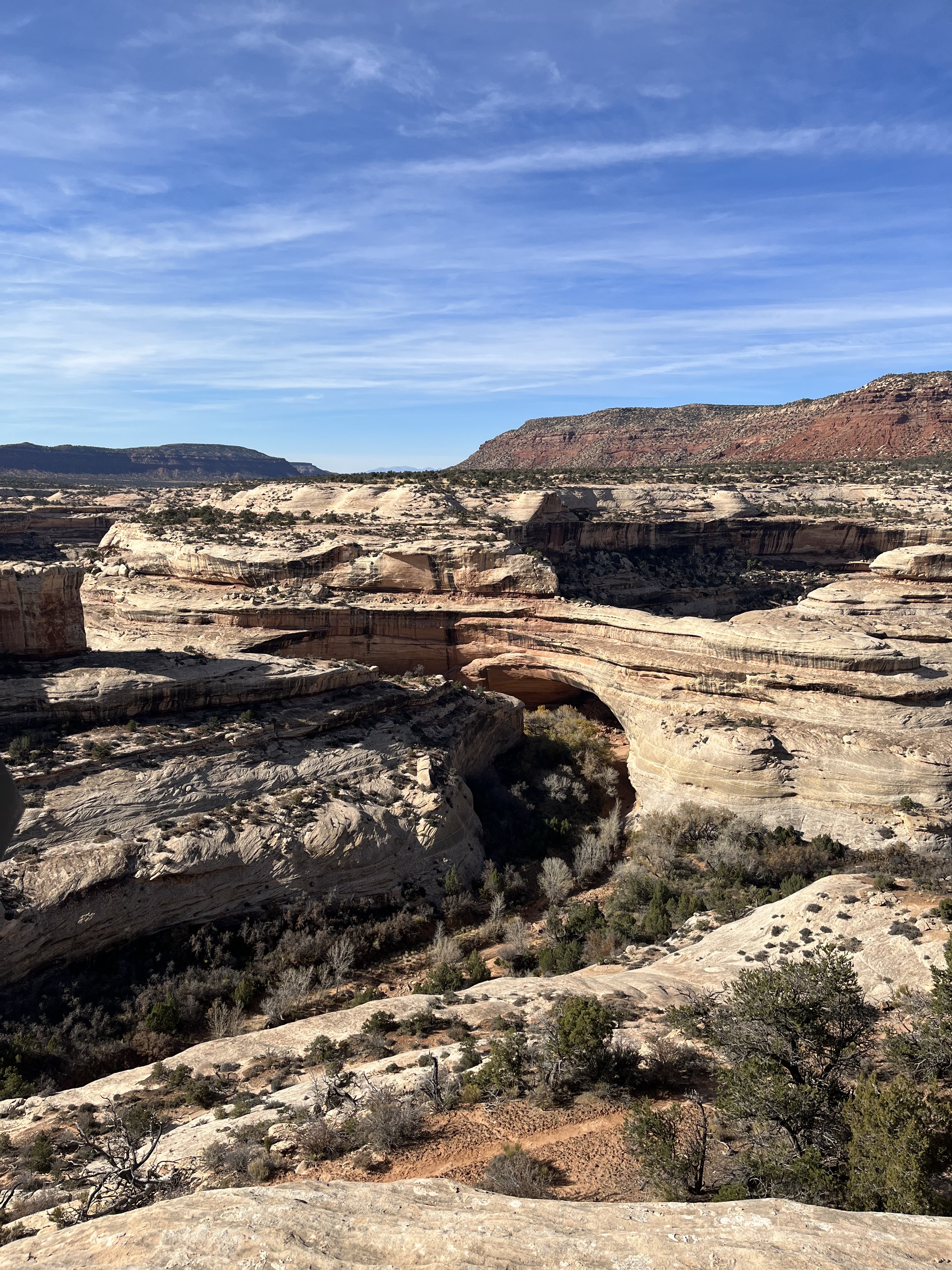
After a stop at the visitor center, we headed to the Slickrock Trail. It is a 2.4 mile trail, primarily on slickrock, which is a smooth rock.  Lots of ups and downs and climbing, but slickrock provides sure footing.  The trail is marked with ‘cairns’.  In Canada, the Indians call them inukyuks.  These are rocks that are stacked about a foot high.  The cairns are positioned where you can see them from one another and follow the trail.


There are several viewpoints along the trail of canyons, and oh, more stunning rockscapes.  And it is not crowded in the least.  We followed the ups, the downs the overs and the sideways.  Although the thermometer said 46, the sun made it warm enough to shed our outer layers.  It was perfect for hiking.  By the end, Spouse was a bit tired.  So we drove and explored a bit.  There are quite a few 4wd tails here.  Some of them are highly technical (no thanks).  We ended up at Cave Springs. 

This is a short .6 mile hike that goes by an abandoned cowboy camp from way back when.  The camp is under a rock overhang.  This was once an Indian refuge, no doubt.  At one point under the overhang is a spring with maidenhair ferns growing out of it.  Many of the plants had identifiers.  Did you know that the Great Basin Sagebrush is of the sunflower family, whereas the herb sage is of the mint family? (Kathy, I know you know this!).  We weaved our way around the overhang to a ladder and climbed it up the wall.  Then another ladder up the wall.  We followed the cairns around the top of the overhang, with, yawn yawn, more stunning views.  We got back to the truck, then back to Artee… for a while.


As the cocktail hour began…  Spouse gasped that he has lost his left hearing aid!  He had put new batteries in at the Cowboy camp so it must be there.  He checked the truck, Artee, all around.  I know it is right here, but let’s indulge the spouse…

So I put my drink in the freezer for now, and Spouse put his wine…  who knows where and off we went.  We retraced our steps to the visitor center.  Only a few folks there (it was closed) and someone was parked where we had been.  We did not see any pieces so let’s go back to the Cowboy Camp. 

This ought to be easy…  looking for a little hearing aid that is the exact color of the trail.  Piece of cake, right?  We started in the parking lot, and someone was parked exactly where we had been (and we weren’t in a spot, so this was weird!).  We scoured the parking lot for pieces… nothing. 

Onto the trail with two sets of eyes… retracing our steps.  In my heart, I knew we would not find it.  I knew it was in Artee or in the truck (which is a total sty with all the crap we have in the back seat) but it wasn’t showing itself.  Little by little we walked, we climbed the ladder.  I told Spouse to continue on and I would go backwards and maybe it would be different.  No…  no luck.  I tried to look in the sty back seat, but nothing.

We got back to Artee… nothing.  Spouse finally started taking everything out of the sty… and there it was, hiding beneath things that it couldn’t possibly have gotten underneath, but it did!  What a relief… If he hadn’t found it, would we kill each other?  If this had been his right aid, if he were a pilot, we would have needed to make an emergency landing!  Thankfully, we avoided all that!

Now, where is his wine?  It is in a metal wine glass.  It is not in Artee, not on the picnic table.  Oh, it could not have gotten up and walked away…  Apparently, in his panic, he put it on the rail of the truck and when we left, it fell in the back of the truck.

Where is his head?....  In that short amount of time, my drink froze.  I guess our fridge is really working!